

By Ricky Erway
Last week’s Days Past article detailed the Sitgreaves expedition which mapped the route the Atlantic & Pacific Railroad and Route 66 ultimately followed across Arizona to Kingman. This article focuses on an important role on most expeditions, the illustrator, and on the most notable Arizona expeditionary illustrator, Richard H. Kern -- who offered the world its first glimpses of central Arizona.
In the 1840s, Richard Kern was a painter, lithographer and art teacher at the Franklin Institute in Philadelphia. His scientific illustrations earned him membership in the Philadelphia Academy of Natural Sciences.
 As a man of science and art, Kern was asked to join John C. Fremont’s fourth expedition in 1848 to explore a potential transcontinental railroad route from St. Louis to San Francisco. He and his younger brother Edward served as illustrators, and their older brother Benjamin served as doctor and naturalist. Even though they had the experienced “Old Bill” Williams as a guide, the group ended up lost and hungry during an unusually cold winter in the now-Colorado Rockies. After the deaths of many mules and with dwindling supplies, a party was sent for help. When they didn’t return, the remaining group attempted to follow their route. At this point, the Kerns cached their supplies, sketches and specimens, hoping to return for them. Ten of the thirty-three men died by the time an advance man returned with help and assisted the weakened men to Taos, New Mexico.
Later, Dr. Kern and Bill Williams returned to retrieve the cache but were murdered by Utes in revenge for an unrelated military attack. Few sketches survived, Richard Kern went unpaid and Fremont didn’t publish a report of the expedition.
Despite his unfortunate experiences on the Fremont expedition, Richard Kern signed on to accompany James Henry Simpson on a large military expedition to Navajo country in 1849. Edward went as topographer and Richard to make portraits and illustrate scenery, costumes and ruins. The expedition made the first recorded visit to the ruins at Chaco Canyon, El Morro and Canyon de Chelly, and resulted in a comprehensive map of the New Mexico Territory.
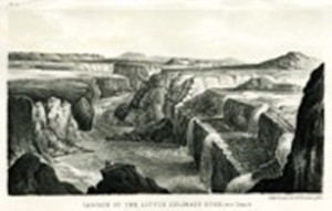
 In 1851, Richard Kern joined the Sitgreaves expedition to follow the Zuni River to the Colorado River to the Gulf of California. While the group was making its preparations in New Mexico, Kern made illustrations of Zuni Indians and the Pueblo of Acoma. Kern was the “draughtsman” on this small expedition party, took scientific measurements and made the expedition map. On the journey to bypass the Grand Canyon and join up with the Colorado River, Kern illustrated the Wupatki Sinagua ruins, but this part of the expedition was dominated by lack of water and trepidation about Indians. The expedition from Zuni to Yuma provided the first reconnaissance for the 35th parallel route to the Pacific.
 The expedition report was published in 1853. Sitgreaves’ portion was no more than 20 pages. In it he said, “I can add very little to the information afforded by the map, almost the entire country traversed being barren, and without general interest.” Others found much that merited attention. The physician and naturalist, S. W. Woodhouse, submitted very detailed accounts on the natural history of the area and of the mammals, birds, reptiles, fish and botany encountered. A significant portion of the report consists of Kern’s tables of distances, positions and meteorological measurements; his map of the route; his 23 lithographs of Indians, pueblos, mountains and rivers; and 16 drawings of birds, mammals and reptiles.
In 1853, Kern was appointed to accompany John Williams Gunnison as assistant engineer, topographer, and artist on a government survey of the 38th parallel, roughly the route of the ill-fated Fremont expedition. This route was in contention with the 35th parallel route, which Kern favored, for the transcontinental railroad. Kern, Gunnison and six other men were killed by Utes in revenge for an attack by Mormon immigrants.
While the goals of these expeditions were not always met, much was contributed to the early understanding of the New Mexico Territory and of what is now central Arizona. Subsequent expeditions used the maps and built on the knowledge acquired in those early expeditions.
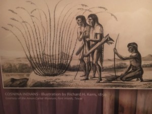
Richard Kern’s role in the expeditions may seem minor, but his impact was significant. He provided the government and the public with the first known drawings of the Mohave, Havasupai and other Pai people. He provided early views of the landscapes and of ancient ruins and petroglyphs. He contributed to the understanding of native flora and fauna of the southwest. And he no doubt inspired those who would later migrate to these lands.
“Days Past” is a collaborative project of the Sharlot Hall Museum and the Prescott Corral of Westerners International (www.prescottcorral.org). This and other Days Past articles are also available at https://sharlothallmuseum.org/articles/days-past-articles.l. The public is encouraged to submit proposed articles and inquiries to dayspast@sharlothallmuseum.org. Please contact SHM Library & Archives reference desk at 928-445-3122 Ext. 2, or via email at archivesrequest@sharlothallmuseum.org for information or assistance with photo requests.