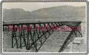
Navajo Bridge
details
Stella M. Jordan Unknown 1015.0117.006.jpg BR-117 B&W 1015-0117-0006 1015.0117.0006 Print 3x5 Historic Photographs c. 1929 Reproduction requires permission. Digital images property of SHM Library & ArchivesDescription
This photo shows the original Grand Canyon Bridge, later named Navajo Bridge, just after it opened to traffic in 1929.
Construction of the original Navajo Bridge began in 1927, and opened to traffic in 1929. The Kansas City Structural Steel Company built the steel spandrel bridge design, which spans Marble Canyon, 470 feet above the Colorado River, in Grand Canyon National Park. The original bridge was 834 feet in length and offered an eighteen-foot surface width with a load capacity of twenty-three tons. At the time of its opening, it was considered the highest steel arch bridge in America. It provided a vital transportation link over the Grand Canyon between northern Arizona and southern Utah. The bridge replaced Lee’s Ferry as the sole crossing of the Colorado River within a distance of 600 miles. The project was paid for by the newly formed Arizona State Highway Commission, later named Arizona Department of Transportation, and in cooperation with the United States Department of the Interior's Bureau of Indian Affairs, as the eastern landing of the bridge is on the Navajo Nation.
By 1990, officials decided that the traffic flow was too great for the original bridge and that a new solution was needed. The sharp corners in the roadway on each side of the approach had become a safety hazard due to low visibility, and deficiencies resulting from the original design's width and load capacity specifications were becoming problematic. The bridge had also become part of U.S. Route 89A. The final decision was to build a stronger and wider parallel bridge beside the existing structure. The new bridge was completed in 1995 and was constructed of high strength steel in order to be visually compatible with the historic bridge and the setting. The original structure remains in service as a pedestrian and equestrian crossing and was listed on the National Register of Historic Places on August 13, 1981. It has also been designated as a Historic Civil Engineering Landmark.
Sources: U. S. Department of Transportation – FHA, American Society of Civil Engineers
Purchase
To purchase this image please click on the NOTIFY US button and we will contact you with details
The process for online purchase of usage rights to this digital image is under development. To order this image, CLICK HERE to send an email request for details. Refer to the ‘Usage Terms & Conditions’ page for specific information. A signed “Permission for Use” contract must be completed and returned. Written permission from Sharlot Hall Museum is required to publish, display, or reproduce in any form whatsoever, including all types of electronic media including, but not limited to online sources, websites, Facebook Twitter, or eBooks. Digital files of images, text, sound or audio/visual recordings, or moving images remain the property of Sharlot Hall Museum, and may not be copied, modified, redistributed, resold nor deposited with another institution. Sharlot Hall Museum reserves the right to refuse reproduction of any of its materials, and to impose such conditions as it may deem appropriate. For certain scenarios, the price for personal usage of the digital content is minimal; CLICK HERE to download the specific form for personal usage. For additional information, contact the Museum Library & Archives at 928-445-3122 ext. 14 or email: orderdesk@sharlot.org.


