


General George Crook & Apache Chiefs
details
Baker & Johnson Unknown 1650-0159-0005.jpg MIL-159 B&W 1650-0159-0005 MIL-159pe Print 11x14 Historic Photographs 1881 Reproduction rights are not available. Owned by another institution.Description
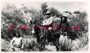
General George Crook, on his mule named " Apache," with Apache Chief Al-Chi-Say and Ba-Keitz-Ogie, (The Yellow Coyote) called "Dutchy." These scouts are in native dress with gunbelts and guns nearby.
Upon his arrival at Fort Whipple in 1871, Crook quickly began using mules in pack trains to support his many Indian campaigns. He preferred to ride his mule named “Apache” rather than a horse. The April 11, 1866 Arizona Miner contained the following excerpt from General Mason’s general order: “...officers when traveling on public service without troops … will ...be furnished...one saddle mule and one pack mule.” The U.S. Army regularly used pack mules to carry supplies, including ammunition and artillery, throughout their campaigns.
In 1871, General George Crook came to Arizona Territory as Commander of the Department of Arizona. His orders were to subdue the Indians of the Territory and place them on reservations. In August of that year, General Crook left Fort Apache with a unit of cavalry troops to locate and mark a supply road from Fort Apache to Fort Whipple in Prescott. It was rough going but the trekkers found water in small lakes. Crook pushed on, and in early September of 1871, he reached Fort Whipple in Prescott.
Actual construction of a road started in the spring of 1872. By 1873, supplies began moving by pack train from Fort Verde to Fort Apache. One year later in September 1874, the first wagon supply train left Fort Whipple for Fort Apache. Martha Summerhayes, the first woman to travel over the road, was on that trip. She later wrote the book, Vanished Arizona, telling of her experiences on the road and describing her travels in Arizona Territory. During the next 22 years, Crook Road was used by troops patrolling across the Territory and the northern boundary of the Apache Reservation. The road was in continual use for 32 more years, until the Rim Road was built in 1928.
NOTE: This photograph is owned by the Smithsonian Institution, Bureau of American Ethnology, National Museum of Natural History (U.S.), Department of Anthropology.
Citation: Photo Lot 24 SPC Sw Apache NAA 4877 Baker & Johnston 02028600, National Anthropological Archives, Smithsonian Institution
Purchase
To purchase this image please click on the NOTIFY US button and we will contact you with details
The process for online purchase of usage rights to this digital image is under development. To order this image, CLICK HERE to send an email request for details. Refer to the ‘Usage Terms & Conditions’ page for specific information. A signed “Permission for Use” contract must be completed and returned. Written permission from Sharlot Hall Museum is required to publish, display, or reproduce in any form whatsoever, including all types of electronic media including, but not limited to online sources, websites, Facebook Twitter, or eBooks. Digital files of images, text, sound or audio/visual recordings, or moving images remain the property of Sharlot Hall Museum, and may not be copied, modified, redistributed, resold nor deposited with another institution. Sharlot Hall Museum reserves the right to refuse reproduction of any of its materials, and to impose such conditions as it may deem appropriate. For certain scenarios, the price for personal usage of the digital content is minimal; CLICK HERE to download the specific form for personal usage. For additional information, contact the Museum Library & Archives at 928-445-3122 ext. 14 or email: orderdesk@sharlot.org.