


Camp Date Creek, Arizona
details
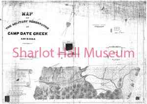
Wheeler, G.M. U.S. Army Corps of Engineers 1760.0160.0000.jpg Historic Maps Collection B&W 1760.0160.0000 1760.0160.0000 Print 5x7 Maps c. 1869 Reproduction requires permission. Digital images property of SHM Library & ArchivesDescription
Map of Camp Date Creek Military Reservation. Camp Date Creek was established in 1867 and moved three times before closing in 1874, when it was deemed of no further use by the Secretary of War. It was originally established to protect miners and settlers who were mostly congregated at Skull Valley and Walnut Grove, as well as the wagon road from La Paz on the Colorado River.
Purchase
To purchase this image please click on the NOTIFY US button and we will contact you with details
The process for online purchase of usage rights to this digital image is under development. To order this image, CLICK HERE to send an email request for details. Refer to the ‘Usage Terms & Conditions’ page for specific information. A signed “Permission for Use” contract must be completed and returned. Written permission from Sharlot Hall Museum is required to publish, display, or reproduce in any form whatsoever, including all types of electronic media including, but not limited to online sources, websites, Facebook Twitter, or eBooks. Digital files of images, text, sound or audio/visual recordings, or moving images remain the property of Sharlot Hall Museum, and may not be copied, modified, redistributed, resold nor deposited with another institution. Sharlot Hall Museum reserves the right to refuse reproduction of any of its materials, and to impose such conditions as it may deem appropriate. For certain scenarios, the price for personal usage of the digital content is minimal; CLICK HERE to download the specific form for personal usage. For additional information, contact the Museum Library & Archives at 928-445-3122 ext. 14 or email: orderdesk@sharlot.org.