Thomas "Tom" Higley
details
Unknown Unknown po0965p.jpg PO-0914 B&W 1700-0914-0008 po0965p Print 6x9 Historic Photographs 1898 Reproduction requires permission. Digital images property of SHM Library & ArchivesDescription
Thomas "Tom" Higley (b. 1888 - d. 1961) was born October 22, 1888. He was the second son of Stephen Weaver (S.W.) Higley (b. 1857 – d. 1935) and Sarah Henson Higley (b. 1867 - d. 1890). He served with the Marines in World War I. He married Lemmie Stauffer (b. May 27, 1886 - 1976), who was born in Kansas. They had one child, Thomas Stephen Higley (b. 1913 - d. 2006). In 1929, he founded Tom’s Tavern, an historic Phoenix bar and restaurant which was a gathering spot for politicians, lawyers, judges, and other professionals until it closed in 2017.
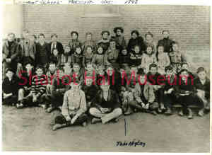
In this photograph, he is shown with his Convent School class in 1898. He is in the second row in the center.
Sources: Images of America, Historic Heritage Square, Donna J. Reiner, PhD, John Jacquemart, and Douglas C. Towne, Arcadia Publishing, 2013; https://www.azcentral.com/story/entertainment/dining/2017
Purchase
To purchase this image please click on the NOTIFY US button and we will contact you with details
The process for online purchase of usage rights to this digital image is under development. To order this image, CLICK HERE to send an email request for details. Refer to the ‘Usage Terms & Conditions’ page for specific information. A signed “Permission for Use” contract must be completed and returned. Written permission from Sharlot Hall Museum is required to publish, display, or reproduce in any form whatsoever, including all types of electronic media including, but not limited to online sources, websites, Facebook Twitter, or eBooks. Digital files of images, text, sound or audio/visual recordings, or moving images remain the property of Sharlot Hall Museum, and may not be copied, modified, redistributed, resold nor deposited with another institution. Sharlot Hall Museum reserves the right to refuse reproduction of any of its materials, and to impose such conditions as it may deem appropriate. For certain scenarios, the price for personal usage of the digital content is minimal; CLICK HERE to download the specific form for personal usage. For additional information, contact the Museum Library & Archives at 928-445-3122 ext. 14 or email: orderdesk@sharlot.org.


