


Gladiator mines
details
A. E. Suppiger A. E. Suppiger 1600.0288.0002.jpg M-422 B&W 1600-0422-0022 m0288pb Print 6x9 Historic Photographs 1903 Reproduction requires permission. Digital images property of SHM Library & ArchivesDescription
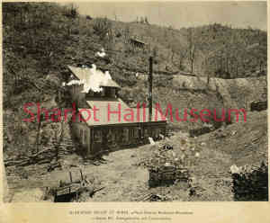
Gladiator mines, Peck District, Bradshaw District, Yavapai County, Arizona Territory.
Gladiator Mines, Peck District, Yavapai County, Arizona Territory, c. 1890.
Handwriting on back of photograph says: “Gladiator Mine, Peck Mining District, 5 miles north of Crown King.”
The Gladiator Mine was a silver and gold mine located in Yavapai county, Arizona at an elevation of 7,021 feet. Years of production were from 1917 to 1951. Other names for the mine included the War Eagle and the Rattlesnake Shaft.
The mine was first located in early 1890's; first recorded production was in 1917. Past operators included E. M. Moore, of Davis, California, dba Gladiator Mining Co., (1951).
The diggings.com website (https://thediggings.com/mines/16317) provided the following description: “The Gladiator Gold Mine was located in close proximity to Cleator, Arizona, within the Tiger Mining District, which now falls under the jurisdiction of the Prescott National Forest. This area has a rich historical association with mining activities, with the site of the mine being initially discovered in 1892. The Gladiator Gold Mine operates as an underground mining operation, with production commencing in 1917. The overall output from the mine has been relatively small. The mine primarily consists of underground workings, with a single known shaft. The maximum subsurface depth reaches 216 meters (710 feet), extending over a length of 1,372 meters (4,500 feet). The ore extracted from the Gladiator Gold Mine predominantly consists of sphalerite, chalcopyrite, and tetrahedrite. The waste material generated during the mining process mainly comprises calcite and quartz. The ore body at this location is described as tabular, with dimensions of approximately 457 meters (1,500 feet) in length, 213 meters (700 feet) in width, and 1 meter (4 feet) in thickness. The mineralization found in the Gladiator Gold Mine dates back to the Paleocene epoch, around 66.00 to 56.00 million years ago. Geomorphologically, the surrounding area is characterized by the Mexican Highland of the Intermontane Plateaus.”
Purchase
To purchase this image please click on the NOTIFY US button and we will contact you with details
The process for online purchase of usage rights to this digital image is under development. To order this image, CLICK HERE to send an email request for details. Refer to the ‘Usage Terms & Conditions’ page for specific information. A signed “Permission for Use” contract must be completed and returned. Written permission from Sharlot Hall Museum is required to publish, display, or reproduce in any form whatsoever, including all types of electronic media including, but not limited to online sources, websites, Facebook Twitter, or eBooks. Digital files of images, text, sound or audio/visual recordings, or moving images remain the property of Sharlot Hall Museum, and may not be copied, modified, redistributed, resold nor deposited with another institution. Sharlot Hall Museum reserves the right to refuse reproduction of any of its materials, and to impose such conditions as it may deem appropriate. For certain scenarios, the price for personal usage of the digital content is minimal; CLICK HERE to download the specific form for personal usage. For additional information, contact the Museum Library & Archives at 928-445-3122 ext. 14 or email: orderdesk@sharlot.org.